GPS or with longer name “Global Positioning System” is an American technology. Initially it was launched on 1978 to be used for USA Military System. The 24 satellite system became fully operational in 1993. First name was called as “Navigation System Using Timing and Ranging“, then “NAVSTAR GPS” and finally just “GPS“.
Today, the GPS is a multi-use, space-based radio navigation system owned by the US Government and operated by the United States Air Force.
On September 1, 1983 Korean Air Lines flight from New York City to Seoul was shot down by a Soviet interceptor when it entered Soviet airspace. After this incident former USA president Ronald Reagan ordered that the Global Positioning System would be made available for civilian use. The GPS signal should be shared freely to avoid such kind of tragedies.
What is GPS and how it works?
GPS provides geographical location and time information to the receivers (today most of mobile phones have own GPS receiver) anywhere on the Earth.
Currently 32 operational GPS satellites are exist and they are moving around the Earth. In 24 hours they complete two circles with roughly 11265 km/h speed.
They are approximately located 20200 km above us. The power source of satellites are solar panels, which seems as wings.
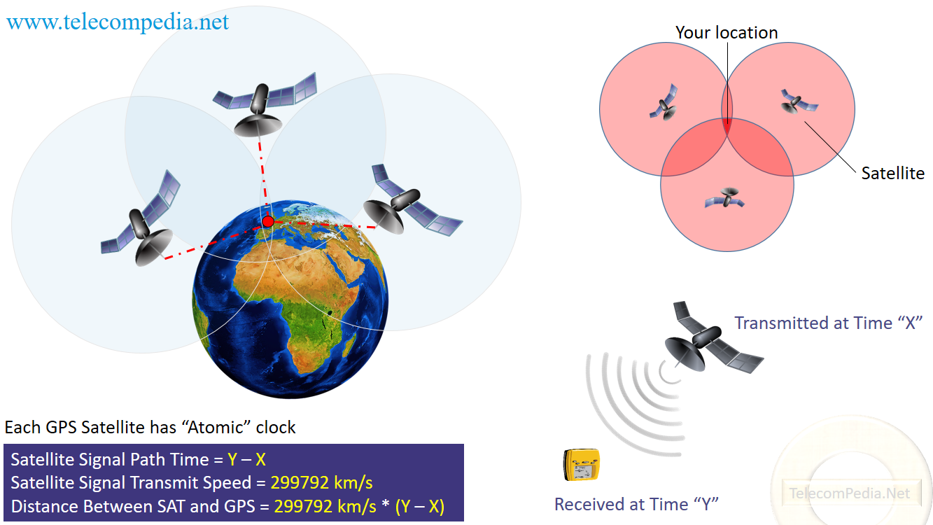
Each satellite continuously transmits a unique low signal and orbital parameters that allow GPS receivers to decode and compute the location of the satellite. GPS receivers use this information and trilateration (using in geometry) to calculate a user’s location. Most of the GPS receivers cannot decode signals under trees, inside building because of low signal are being transmitted by the satellites.
• 2D calculation: at least three satellites are required for Latitude & Longitude
• 3D calculation: at least four satellites are required for Latitude, Longitude and Altitude
• All GPS satellites are using Atomic Clock (highly accurate)
With simple explanation, to find user location need to have three information:
• Satellite signal path time which is difference between received time and transmitted time.
• Satellite signal transmit speed which is same with light speed (299792 km/s).
• Distance between Satellite and GPS receiver, which the calculation is shown on the picture.
Generally this system is called as Global Navigation Satellite System, and some other countries have similar systems:
✸ USA: GPS
✸ European Union: Galileo
✸ Russia: GLONASS
✸ China: BeiDou
✸ India: NAVIC
Mainly two of them, GPS and GLONASS are navigational systems with global coverage
Thanks in favor of sharing such a pleasant idea, article is nice, thats why i
have read it completely